(by Andy Sewell, originally posted February 11, 2013)
One of the biggest archaeology stories to hit the news recently has been the discovery of the remains of Richard III, the last Plantagenet king of England, underneath a parking lot in Leicester, England. Richard III (1452-1485; ruled 1483-1485) was killed in battle, and buried at Greyfriars friary. Over the years, the knowledge of the grave’s location was lost to history, and successive waves of building at the location led many to assume the site was destroyed over time. However, a project specifically designed to locate Richard’s remains was conducted by a joint effort of the University of Leicester, the Leicester City Council, and the Richard III Society. Using historical maps, the team identified the former location of Greyfriars, under a modern parking lot, and began excavations. Very quickly, the team found a burial of an adult male, showing evidence of death in battle and exhibiting a spinal deformity, matching the physical description of Richard III (Shakespeare famously described him as “deformed” and “unfinished” in his play Richard III). DNA testing of descendants of the Plantagenet line confirmed that the body was in fact that of the king. Richard III apparently suffered mortal wounds to the head, and received other wounds at or just after death, likely by Tudor soldiers who intended to desecrate the body. Richard’s body was displayed publically, then buried in the garden at Greyfriars.

What is truly notable about the discovery of the remains of Richard III is the fact that the grave survived intact over centuries of development. All too often, urban archaeological projects must face the preconception that development over the years has erased all traces of what was there before. Urban archaeologists, however, are well aware this is not always the case. In fact, as the discovery of Richard III attests, significant archaeology sites are often just below our feet as we go about our daily lives.
In the United States, the most famous (and perhaps infamous) urban archaeological site is the African Burial Ground in New York City. The burial ground operated as a cemetery for New York City’s enslaved African population from ca. 1690 to 1794, and was filled over in the nineteenth century to prepare the land for development. A department store was built on the site in 1846. In 1991, a new federal office building was planned for the site. Although planners were aware that the location was formerly a burial ground, they assumed that the site had been completely destroyed through two centuries of urban development. However, burials began showing up during the excavation of the building’s foundation, setting off a controversy that was finally resolved with the redesign of the project to avoid areas predicted to have the highest probability for intact burials and the dedication of a memorial on the site. Study of the excavated remains have yielded much information about the lives of New York City’s earliest African-American inhabitants.
Important archaeological sites in urban locations are not only associated with the people who lived in those communities, but with populations that lived hundreds and even thousands of years before. Even today, excavations in East St. Louis, Illinois, continue to find evidence of Mississippian urbanization associated with the mound center of Cahokia. Excavations associated with a new bridge project have uncovered thousands of house patterns and the base of a previously unknown pyramid mound, in an area that was formerly industrial in nature. Closer to home here in Columbus, Hardlines Design Company has participated in urban archaeology projects of much lesser scale than those in Leicester, New York, or East St. Louis, but prove nonetheless that significant archaeology sites can exist under the modern urban landscapes of Ohio.
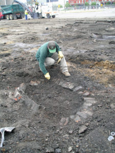
In 2007, Hardlines conducted limited archaeological testing at the location of the new Franklin County Courthouse at Mound and High streets in downtown Columbus, Ohio. The objective of the dig was to test the proposition that there were areas within the new courthouse location with intact archaeological deposits. After removing the asphalt in the archaeological testing area, archaeologists uncovered two building foundations, two brick-lined privies, a brick path, and a possible unlined privy, plus two other possible shaft features were noted outside the area where the pavement was removed. One test unit recovered 677 artifacts, including 554 historical artifacts, 17 prehistoric artifacts, and 106 faunal remains. The soil layers appear to be intact, with the oldest (prehistoric) artifacts located in the deepest soil layers and the youngest artifacts nearest the surface, with limited mixing of material. Due to the nature of the project and its funding sources, no further archaeological excavation was performed; however, the limited excavations at the site demonstrated that there is a great potential for the discovery of significant archaeological sites within the urban core of Columbus.
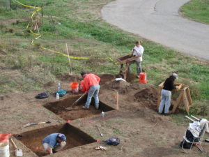
Further afield, Hardlines performed intensive excavations at a Late Prehistoric/Fort Ancient site in Lawrence County that was under a late twentieth century subdivision. Despite disturbances from nineteenth century agricultural practices and twentieth century house construction and installation of utilities such as septic tanks, several intact prehistoric features were found during excavations, often just next to modern disturbances. Large numbers of artifacts, including lithic tools, pottery, and food remains, were recovered from these features.
Finally, Hardlines has been working on a project at Salem Maritime National Historic Site in Salem, Massachusetts, investigating the site of the earliest warehouse on Derby Wharf, dating to 1765. The project is ongoing, but has demonstrated that despite nearly two hundred years of development and landfilling, and subsequent land disturbance through renovations of the wharf by the National Park Service, evidence for the warehouse is still present at the location.
What does all this mean for assessing the probability that a significant archaeological site is located in an urban setting? Well, while it is highly unlikely that your parking lot is covering the burial of a king, it is possible that an important archaeological site could be present. How does one go about determining if this is the case? Thorough research into the land use history of a parcel is one key component, using historical maps, photographs, and other documents. Especially useful are Sanborn fire insurance maps, which can be used to construct a detailed picture of development on a piece of property over time. Identifying building locations and landfilling episodes are key to locating areas where archaeological sites may survive, as well as documenting locations that are thoroughly disturbed. Knowledge of prehistoric cultural lifeways is critical, as many cities and towns are located in areas that were highly attractive for settlement in the pre-Columbian period: close to water, elevated above flood plains, and well-drained. Finally, archaeological testing of your property is always a good idea if you cannot determine with research that there is no possibility for survival of archaeological deposits through development. Keeping the possibility of intact archaeological sites at an urban development site in mind and accounting for it in project planning may pay off in avoiding controversy at a later date, even if there are no funding or permitting requirements calling for archaeological assessment of the project location.